Artists and historians will be exploring the Tame and the area around, and the individual journeys through Witton and Perry Barr of residents past and present. There will be lots going on, including events, workshops, printed work and exhibitions for the whole community to get involved in.

Friday 20 March 2015

Salford and Spaghetti

The caves on the River Tame, also known as the Dwarf-holes, c. 1895 by Benjamin Stone.
The caves were removed in the 1960s when Spaghetti Junction was built. 

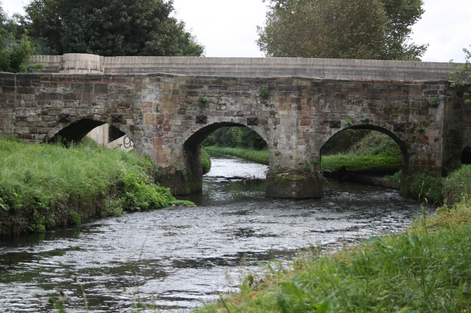
Salford is an ancient crossing of the River Tame which is situated almost immediately under Spaghetti Junction. The word ‘ford’ means crossing and the word ‘sal’ has been transformed from ‘scraet’ or ‘scraf’ meaning caves, and there were indeed caves here until Spaghetti Junction was built (see image above). So this is the crossing by the caves; the caves were first mentioned in the late 1400s, and at the time were called ‘Dwerffeholes’. There is also a brook that joins the river here called Hawthorn Brook, which is difficult to find as it now mainly flows underground, but traces of it can be discovered along the Tame Valley canal nearby. Hawthorn was a healing tree in ancient traditions, so the caves could possibly have had a mystical purpose with people leaving tokens inside, but their original use is long forgotten, so this is just speculation. What is known is that the caves were used in World War II to shelter from bombing, and the area around was heavily bombed due to the many industries all around that made weaponry and machinery.

The reason that there was a crossing here was that the ground was gravelly, which made it easier for horses and carts to get across the river, and the gravelly nature of the ground is why the nearby area is called Gravelly Hill. Eventually a wooden bridge was built, first mentioned in 1290; in 1538 a traveller called John Leland noted that a new stone bridge had been erected; he states: “A mile beyond Bremischam [Birmingham] I passyd over Sharford-bridge of 4. arches of stone. Tame river goythe under this bridge […]. There be faire medows about Sharford-bridge”. The scene today, with the long concrete legs of Spaghetti Junction towering up to the curving roads, is a long way off the ‘fair meadows’ of the 1500s.

This bridge was abandoned over 200 years ago and a new one was built a little further downstream, and called Salford Bridge. The old bridge, neglected, slowly crumbled away, and anything that may have remained, would have been removed when Spaghetti Junction was built.

Spaghetti Junction being built in the late 1960s.
The River Tame is just visible to the right.

The old Salford or Scraford is today where Spaghetti Junction rises, which is the nickname for what is formally called the Gravelly Hill Interchange. It was opened on 24th May 1972 and is a complex entwining of roads, so much so that one of the men who helped build it, Les Smith, got lost when he first used it! Les is very proud as being part of the building of Spaghetti Junction: “It was something brand new, it was like giving you a Christmas present….you know you are building something that is going to be worthwhile…..it’s world famous now, I mean, you see it on the television…..something I can pass down to my children…..grandchildren”. He also remembers how they tried to divert the River Tame, but that it “didn’t want to be diverted, it broke its bank a few times, went back to its original form”.

As you walk near Spaghetti Junction you will notice a lake on the other side of the River Tame, known as Salford Lake. This is possibly the oldest reservoir for drinking water built in Great Britain, and was part of the Birmingham Street Commissioners proposals to get clean drinking water into Birmingham in the 1830s. Both the River Tame and Hawthorn Brook were utilised, and further north the lake in Brookvale Park and Upper Witton Lake are traces of the scheme along the Hawthorn Brook. Many years ago Salford Lake was used for motorboat racing, and the park around for an annual festival with rides and fireworks.

A brand new Spaghetti Junction in the early 1970s. 

Monday 17 November 2014

Holford and Holford Mill

The River Tame in Holford, in the heart of industrial Witton (2014).
Holford Industrial Estate stands on both banks.

Following out 'Ramble & Babble' last Wednesday, some questions about the history of places along the Tame came up......I will, in the next few posts, attempt to answer them.

#1. What is the 'Holford' part in Holford Industrial Estate ?

The Holford area of Witton, where the Holford Industrial Estate stands today, has a long history relating to an ancient crossing (the meaning of the word 'ford' is crossing point) of the river Tame. The 'hol-ford' was probably at Perry Bridges, where the Holbrook joins the Tame, as this was a prominent crossing point dating back to Roman times. The 'hol' part of the name probably relates to the word holm which is a water meadow,* so Holford was the crossing near the water meadows.


Perry Bridges, two bridges on the Aldridge Road, the closer dating from 1711.


EARLY HISTORY
The water of the river Tame in Holford was used to power a mill from, at least, 1228, when a document of "William le Holdere of Honesworth", or, William the holder of Handsworth, notes a highway towards the mill of Holford. It is thought that this was a fulling mill used for hammering wool to remove wool and dirt, so there would have been sheep farming nearby. Like many mills along the River Tame, it was converted in the 1500s from a fulling mill  to a hammer mill, hammering iron to remove the carbon and strengthen the metal; this had happened quite early at Holford, at least by 1533.** By the 1650s the site had been converted to a blade mill, grinding edge tools such as scythes, swords and axes.

METAL ROLLING
Between 1765 and 1781 Matthew Boulton of the Soho Works rented Holford Mill for metal rolling,*3* but it is likely that it was occupied with a dual purpose, with the water-power still being used for grinding tools as well. By 1815 it had been taken over by Thomas Wilmore of Birmingham, a 'manufacturer of rolled, plated, gilding and dipping metal, wires etc.'*4*

THE MANUFACTURE OF AMMUNITION
In the early 1870s the mill was acquired by Westley Richards, an old Birmingham gun making company, and Holford was used as they began in the production of ammunition. This was short lived, and throughout the Victorian period Holford Mill passed through a number of hands, but all the time producing ammunition for sport and for the wars of the period. By 1910 the site was neglected and run down, so was taken over by the neighbouring Kynoch ammunition factory, and became part of that vast site. The actual mill, a two-storied brick building, was being used as an office and store in the 1950s, though the waterwheel itself had been removed.

Advert for the National Arms & Ammunition Co. at Holford, 1873.


A Grenfell & Accles Ltd. exhibition, 1891.

Advert for Grenfell & Accles Ltd, 1890s.
Part of Holford in 1947, with the Tame still separated into two branches.
The closer one was the millrace used to power the original mill. 

NOTES
* Victoria County History- http://billdargue.jimdo.com/placenames-gazetteer-a-to-y/places-h/holford/
** The Tame Mills of Staffordshire, D. Dilworth
*3* Matthew Boulton: Enterprising Industrialist of the Enlightenment, edited by Mr Kenneth Quickenden, Ms Sally Baggott, Dr Malcolm Dick
*4* Wrightson's Triennial Directory (1815)

Monday 27 October 2014

Ramble & Babble 2014


The map below shows the meeting place for the walk. This spot has been chosen as Rob Colbourne and Stuart Mugridge are designing an area here for public use here, including a river viewing platform as part of the flood defence work in Witton.

Thursday 16 October 2014

Industrial & River Onomatopoeia


Sounds collected from the river and the local industries around Witton and along the wider Tame area, by Jenni, school children, and with the help of some of the local industries who have showed us round.

Friday 4 April 2014

Upstream:Downstream (Part Two- Witton Bridge)


Over April there is a piece of work (that will be added to over the month) on both Holford and Witton Bridges. The work on the UPSTREAM side of  Witton Bridge (above) explores the history of the River Tame; each jam jar contains a photograph of the river through its history, and memories, poetry and thoughts about the river heritage. On the DOWNSTREAM side (below) are thoughts collected from various parts of the Tamed project, including the Mobile Drawing Studio, Deykin Avenue School and art workshops, exploring the here & now and the future of the River Tame.


The builders working on Witton Bridge looking at some of the jam jars.

Upstream:Downstream (Part One- Holford Bridge)


Over April there is a piece of work (that will be added to over the month) on both Holford and Witton Bridges. The work on Holford Bridge explores the history of life along the River Tame; the UPSTREAM side looks at the places along the way to Witton from the river's source, the DOWNSTREAM side explores Witton's industrial history which sat along the Tame as the river flows through towards the Trent and the ocean.

Each jam jar contains a memory and photograph collected from along the Tame.


The Witton News: Issue Three Out Now!

The latest issue of The Witton News is out now!

This issue is all about Witton sounds.....both the industrial noises of Witton's past and present and the more gentle sounds of the River Tame.

You can get a copy from most of the local Witton shops and cafes, including the Tame Road Stores, and the newsagents on Electric Avenue. If you would like copies of previous issues please contact jenni.colesharris@gmail.com.

We would like to fill the next News with local stories, so if you have something to add, please email jenni.colesharris@gmail.com

Tuesday 12 November 2013

You Are Invited to Ramble & Babble

You can find where to meet on the map, here.

For more information, or to confirm that you would like to attend, please email jenni.colesharris@gmail.com

Tuesday 5 November 2013

Witton Half Term Trail

Thank you to everyone who took part in the Witton Trail this half term, I have collected the trails and will announce the winner soon.
Lots of jam jars full of Witton and River Tame wildlife (including Witton's industrial wildlife, like cars, bikes, cogs and engines) were placed round the streets over half term. Those that took part in the trail followed the clues on their sheets and could discover what the area used to be like, some hidden places in the present, and produce some ideas for what they would like to see happening in the area in the future.
A map was provided with the trail to help people find their way round.


A little more information about parts of the trail.

Why is there a horse in Witton?

Well, horses used to pull carts, you can see some pictures of horses pulling the milk carts in Tame Road here. But, as well as the carts, horses used to pull the canal boats along the canal, as you can see below; the trail took you the part of the canal in the photo, along the Deykin Avenue cul-de-sac, and the house on the right is still there. It used to be the house for the toll keeper, who collected money from those using the canal.
There was also a cow along the trail, where Witton Farm used to be; now this is part of DANA. Near to DANA those on the trail found out where children, who are now in their 90s, used to pick blackberries in the autumn, and the noises that all the metal manufactories used to make.


PRESENT WITTON


 Gears

Around Electric Avenue and Tame Road there were lots of clues about all of Witton's industry; WILD makes parts which can be found in most people's cars, plus bikes, engines and all sorts of other things are still made in the area. Many of Witton's items travel all across the country and to the rest of the world, like Germany, Turkey, Pakistan, India, Brazil, China and many other places.

FUTURE WITTON

There were some great drawings produced for how Witton could be added to, and how some of the empty buildings and spaces could be used.

I will add these to some separate posts as they were so good.

Drop-in Art Workshop


On 11th October, during the drop-in session with the Environment Agency, Tamed held an art workshop at the Community Centre. First the year four children came over from Deykin Avenue Junior's, and then, after school, the workshop was open to anyone else who wanted to attend.
On the floor we laid down paper and painted a large image of the River Tame. The children could make animals that either live on the river now, or we would like to see living on the river in the future. They then built a habitat (house) for their animals along the river.
A colourful butterfly.
An otter and his habitat. It would be lovely to see otters along the river!
A bank vole in a warm, cosy hole in the river bank.
Rabbits can often be spotted along the river in Witton.


After school a lot more animals and habitats were made.


Some children who live locally made a park.
The river was filled with fish.
Tissue and shiny paper makes great water!
The vole lives under the tree, whilst the buzzard looks down from below. Be careful little vole!
The rabbit lives in a burrow underground.
Parents helped to make the habitats.
The river needs lots of trees for animals to make their homes.
Lots of trees!
This tree was put in the park that was made.
This nest was for a heron.
All over, and Witton and the River Tame have some great habitats for lots of different kinds of animals.